The Tallokas-to-Barney Tram
The short rail line west of Barney began as Mitchell Brice's private industrial tram. A newspaper stated in October 1899 that Brice had built and was operating a tram road about seven miles west from Barney to his lumber mills and turpentine still. A 1900 railroad map then drew a branch west from Barney toward Tallokas. A 1901 newspaper placed Brice's mill at Tallokas, and the 1906 Cyclopedia of Georgia called Barney the terminus of a branch of the South Georgia and West Coast system running to Tallokas.[1-3][11]
Those records probably describe the same physical corridor. The newspaper reports and map are consistent with a line west from Barney toward Tallokas, but do not establish every part of its route. What remains missing is the document that would settle the operating relationship. No deed, lease, purchase agreement, operating contract, or corporate minute has been found showing that the South Georgia Railway or the connected West Coast system acquired Brice's tram. In fact, an October 1906 newspaper says the Brice estate sold several miles of rail from the Brice tram road for reuse elsewhere. The most defensible conclusion is that the 1899 Brice tram and the mapped Tallokas branch were the same line, while corporate ownership or formal railway operation remains unproved.[12]
Why the tram was built
Mitchell Brice was a Tallokas farmer, timber operator, turpentine producer, store owner, and county commissioner. Folks Huxford's later account places him on the committee that raised local subscriptions for the railroad being built from Adel through Barney and Quitman; the original committee record has not been located. Contemporary reports named him as a South Georgia Railway director by March 1899. His tram connection suggests that his business used the railway for freight, but no inspected transaction establishes him as a customer.[8]
The tram solved a practical problem. Brice's mills and turpentine still stood several miles west of the new railway. A private track could move logs, lumber, barrels, supplies, and other heavy freight between the woods operation and the station at Barney. The 1899 newspaper does not list the tram's rolling stock, gauge, locomotive, workforce, freight rates, or exact junction. It does make the line's purpose plain by placing its western end at Brice's mills and still.[1]
A 1901 report adds a harder part of that operation. Lee Rogers was killed near "Mr. M. Brice's mill at Tallokas" while supervising a squad of convicts cutting timber for the mill. This directly fixes the mill at Tallokas and shows that convict labor was used in its timber supply. The article does not say whether those workers built or maintained the tram.[11]
This was not the South Georgia Railway main line. The main line ran north and south through Barney, connecting Heartpine and Adel with Morven and Quitman. Brice's tram ran west as an industrial feeder. Barney mattered because it was the place where freight from that feeder could enter the larger railroad system.
The 1899 newspaper record
The clearest contemporary account appeared in a Brooks County profile in the Valdosta Times on October 14, 1899. As the article moved from Barney toward Morven, it reported:
From Barney, Mr. Mitchell Brice, one of the wealthiest men in South Georgia, has built and operates tram road about seven miles west to his large lumber mills and turpentine still.
The surviving page image supports five direct findings. Brice built the line, operated it, connected it with Barney, ran it west for about seven miles, and used it to reach his lumber and naval-stores works. The article does not use the name Tallokas, but seven miles west of Barney reaches the Tallokas neighborhood in which Brice lived and conducted business.[1]
The wording also helps date the line. It was complete and operating by October 1899. The source does not say when construction began. Since the South Georgia Railroad opened through Barney in 1897, the present evidence places construction between the arrival of that main line and the October 1899 profile, unless an earlier tram was later extended to the new station.[1][8]
Another overlooked article suggests that the track could carry people, at least for a private outing. In May 1900, the Atlanta Constitution reported that twenty to twenty-five Quitman residents took a 6 o'clock train to a fish fry and picnic hosted by Mr. and Mrs. M. Brice at Tallokas and returned at 7 p.m. The article does not name the railroad, Barney, or the tram, so it cannot prove scheduled passenger service. It does show train access to a Brice-hosted event at Tallokas during the tram's operating period.[13]
From private tram to named branch
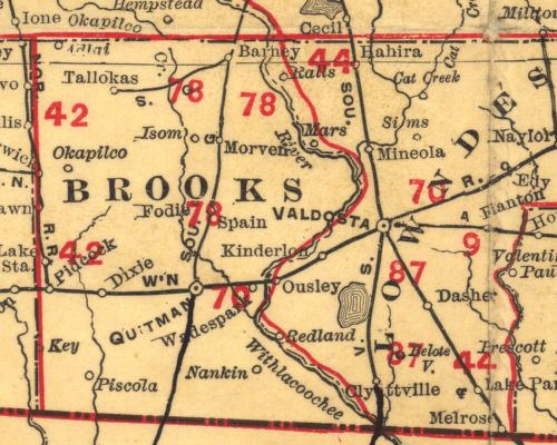
A Rand McNally map published in 1900 depicts a short rail line leaving Barney to the west and bending southwest toward Tallokas. Its general direction is consistent with the newspaper description, but the map's scale does not permit a reliable comparison of length or an exact terminal location. The map does not label Mitchell Brice, identify the owner, or explain whether the track was private or part of the common-carrier system. Its publication date does not establish when the line was surveyed, built, or operating.[2]
The Cyclopedia of Georgia, published in 1906, is more explicit. Its entry for Barney says the town was on the main line of the South Georgia and West Coast railroad and was "the terminus of a branch of the same system that runs to Tallokas." That is the strongest located source for treating the Tallokas line as part of the connected railway system rather than only as an isolated woods tram.[3]
The wording does not tell us how the author understood that relationship. The railway may have operated over privately owned track, or the reference book may have described a traffic connection more loosely than a corporate deed would. Mitchell Brice died in March 1903. The October 1906 rail sale shows that the estate still controlled the tram rails, which weighs against an unsupported claim that the South Georgia Railway owned the track outright.[8][12]
Official common-carrier reporting adds a useful caution. The Georgia Railroad Commission's 1903 material describes the South Georgia route from Heartpine through Barney and Quitman toward Greenville, but it does not list Tallokas as a regular station on the reported main route.[4] This is consistent with a private or industrial branch that connected with the system without becoming a scheduled passenger line. It also means the Cyclopedia should not be stretched into a claim that Tallokas had ordinary passenger service.
Reconstructing the route
The period evidence fixes the broad alignment but not every curve. The 1899 article gives the direction and approximate length. The 1900 map draws the connection west of Barney. The official 1908 Brooks County map identifies Tallokas, Brice Pond, land lots, property owners, roads, and the South Georgia main line, but it does not clearly plot the short branch shown on the 1900 map.[1][2][5]
Later aerial photographs preserve more of the grade. In the 1956 Brooks County series, frame JC-7R-077 shows a strong diagonal abandoned rail alignment west of Barney. Adjacent frames extend the trace in both directions. A feature-level reconstruction places the eastern end near Barney at approximately 31.003984, -83.514150 and the western end near 30.990749, -83.622187. The straight-line distance between those points is about 6.46 miles, close to the newspaper's approximate seven miles.[7]
His reconstruction places the western terminal in Land Lot 457, probably at Brice's mill in the Tallokas area. From there the grade runs northeast through Land Lot 418, reaches the line between Land Lots 412 and 411, and then turns east toward the Scruggs neighborhood and Barney. This is a careful reading of aerial and land-lot evidence, not a surveyed railroad plat. The Brice Mill endpoint remains probable.[6][7]
The agreement in distance is important, but it is not proof by itself. An abandoned grade can be measured without proving its owner or operating date. The route becomes strong probable because the aerial trace also agrees with the 1899 direction, the 1900 mapped branch, and the 1906 Tallokas description.
Lines that should not be confused with it
Several nearby rail projects have been merged in older summaries. They need to remain separate unless a source connects them.
The South Georgia Railway main line ran north and south through Barney. It was the common-carrier route that made Barney a station in 1897.[8]
In March 1899, another report described an Oglesby timber branch planned east or southeast from Barney toward newly acquired timber. Rails and a switch had reportedly been purchased, but the located article does not prove that the project was finished exactly as planned. Its direction and ownership distinguish it from Brice's westbound tram.[9]
The Valdosta, Moultrie and Western later crossed the country west of Scruggs on a different alignment. A 1938 aerial contains traces of both lines in the same general neighborhood. Jones's image reading keeps the east-west Tallokas tram separate from the VM&W grade that ran northwest and southeast through the Scruggs area.[6]
These distinctions matter. A roadbed seen on an aerial photograph is not automatically the Brice tram, and every woods track near Barney did not belong to the South Georgia Railway.
The 1906 dismantling
The best closing evidence was found during this research pass. On October 6, 1906, the Valdosta Times, reprinting the Quitman Free Press, reported that R. R. and Jack Renfroe had bought "the rails used as the Brice tram road from the Brice estate." The purchase consisted of several miles of rail. The Renfroes planned to reuse it on a new timber operation south of Quitman.[12]
That sale establishes that the line was being dismantled, or had already ceased operation and was ready to be dismantled, by October 1906. It does not state the last day a car moved, whether every rail was removed, or when the grade was abandoned. The sale also fits the branch's absence from the official 1908 county map.[5]
The Cyclopedia of Georgia and the rail-sale article both appeared in 1906. The book may have described conditions compiled before the sale, or it may have used "branch" for a connected private tram whose rails remained estate property. The two sources do not justify a corporate-ownership claim.
The 1938 and 1956 aerials document a surviving ground trace, not active rails. By 1956 the best frame shows an abandoned alignment. No photograph of the tram in service, locomotive roster, employee account, construction contract, or exact last-run notice has been found.[6][7]
Evidence verdict
| Claim | Finding |
|---|---|
| Mitchell Brice had a tram operating west from Barney by October 1899. | Verified by a contemporary newspaper. |
| The tram was about seven miles long and served Brice's lumber mills and turpentine still. | Verified by the same report. |
| A rail branch ran from Barney toward Tallokas by 1900. | Verified as shown on the retained 1900 map crop. |
| Barney was described in 1906 as the terminus of a branch of the South Georgia and West Coast system to Tallokas. | Verified as printed in the Cyclopedia of Georgia. |
| Brice's 1899 tram and the 1900 to 1906 Tallokas branch were the same physical line. | Strong probable. The direction, distance, date, destination, and connection agree, but no transfer or operating document has been found. |
| Brice's mill stood at Tallokas. | Verified by the 1901 report of Lee Rogers's death near the mill. |
| The line could carry people. | Possible and supported by the 1900 Brice picnic trip, but the article does not identify the train or tram. Scheduled passenger service remains unsupported. |
| The reconstructed western terminal was Brice Mill in Land Lot 457. | Probable from aerial and land-lot interpretation, not directly proved by a railroad plat. |
| The line was part of the VM&W or the Oglesby timber branch east of Barney. | Contradicted by direction, chronology, and route evidence. |
| The tram had been dismantled or was being dismantled by October 1906. | Verified by the estate's sale of several miles of tram rail. The exact last operating date remains unresolved. |
What remains to be found
The best remaining records would be Brice's complete probate inventory and estate-sale papers, deeds or leases involving his tram, South Georgia Railway and West Coast Railway minute books, industry sidetrack agreements, and the detailed federal valuation maps for the Barney area. National Archives file unit 1561298 contains a set of South Georgia Railway valuation maps from about 1915 to 1920, but the detailed sheets are not online. Even after the rails were removed, those sheets may show the former junction or right of way.[10]
The University of Alabama Map Library catalog identifies the retained map as Rand McNally and Company's Georgia Railroads, published in Chicago in 1900 at a scale of 1:950,000.[2]
Research coverage
This dossier reconciles the preserved 1899 newspaper image, the 1900 picnic report, the 1901 Tallokas mill report, the retained 1900 map crop, the 1906 reference-book entry and rail-sale notice, Georgia Railroad Commission route reporting, the official 1908 Brooks County map, 1938 and 1956 aerial photographs, Brice's full research dossier, and earlier South Georgia Railway work. Local newspaper corpora and online searches covered Mitchell Brice, Tallokas, Barney, tram road, tramway, branch, lumber mill, sawmill, turpentine still, sidetrack, Renfroe, estate, and railroad ownership variants.
Georgia Historic Newspapers searches located the overlooked 1901 mill report and 1906 rail-sale report. A fully paginated review of 91 Tallokas results from 1885 through 1910 found no second article explicitly equating the Brice tram with the Tallokas branch. Search-engine results were sparse, fresh Newspapers.com access timed out twice, newspaper OCR remains imperfect, and some corporate and valuation records are not digitized. The absence of an operating agreement is therefore an unresolved archival gap, not proof that no such document existed.
Sources
- Valdosta Times, October 14, 1899, p. 21, Brooks County profile, Newspapers.com image 889671340.
- Rand McNally and Company, Georgia Railroads (Chicago: Rand McNally and Company, 1900), scale 1:950,000, University of Alabama Map Library, Historical Maps of Georgia, 1896-1900, entry
Georgia1900a. - Allen D. Candler and Clement A. Evans, eds., Cyclopedia of Georgia, vol. 1 (1906), p. 131, entry for Barney.
- Georgia Railroad Commission, Thirty-First Report (1903), South Georgia Railway route and mileage material, pp. 88 and 133, Internet Archive item
reportrailroadc01unkngoog. - Georgia Archives, Map of Brooks County, 1908, County Maps collection, item 285.
- Digital Library of Georgia, Brooks County 1937-38 aerial series, Scruggs-area frame
JC-2A-009, image00188, March 17, 1938, and collection record. The route identifications on this frame are user-verified image readings. - Digital Library of Georgia, Brooks County 1956 aerial series, especially
JC-7R-077, image 73, with adjoining frames 72, 74, 90, and 91. - Mitchell Brice research dossier, including Atlanta Constitution, March 30, 1899, p. 3, image 26826945; Valdosta Times, April 4, 1899, p. 3, image 889670566; and Savannah Morning News, March 9, 1903, p. 5, image 879562699.
- Valdosta Times, March 14, 1899, p. 3, proposed Oglesby timber branch from Barney, Newspapers.com image 889670505.
- National Archives, Valuation Maps of the South Georgia Railway, file unit containing 24 maps, about 1915 to 1920.
- Savannah Morning News, August 11, 1901, p. 22, report placing M. Brice's mill at Tallokas and describing timber cutting by a convict squad, Georgia Historic Newspapers.
- Valdosta Times, October 6, 1906, p. 4, reprinting the Quitman Free Press report that R. R. and Jack Renfroe bought several miles of rail from the Brice estate's tram road, Georgia Historic Newspapers.
- Atlanta Constitution, May 21, 1900, p. 8, Brice fish fry and picnic at Tallokas reached by train, Newspapers.com image 34071214.

