From Irwin to Lowndes and Brooks Counties
Lowndes County organized
Lowndes County was created from Irwin County on December 23, 1825. It initially included the 8th, 9th, 10th, 11th, 12th, 15th, and 16th land districts of original Irwin County. The organizing act approved the next day designated Sion Hall's home for the first courts and elections and named Lawrence Folsom, Hall, William Blair, John J. Underwood, and Daniel McCranie Sr. to select a permanent county site. The Digital Library of Georgia's transcription of the legislative volume renders his name as “Daniel McCraney”; the surname spelling differs in the 1920 reprint.
Hall lived in the Coffee Road neighborhood north of present Morven. An 1846 sheriff's notice placed working saw and grist mills on Hall family property in Land Lot 271; a 1902 correction placed the residence in adjoining Lot 270. In 1826, the statutory court and election place moved to Francis Rountree's home. Later witnesses disagreed about which early Superior Court terms met at each house.
County commissioners selected Franklinville, on Land Lot 50 near the Withlacoochee River, as Lowndes County's first permanent county seat. The small settlement had the county's first courthouse, and Hamilton W. Sharpe later dated its first Superior Court term to the fall of 1829. Franklinville remained the seat of county government until Troupville replaced it in the 1830s.
Several commissioners later held county and state offices. Blair served as an Inferior Court justice and state senator. Henry Blair was the first court clerk and later served as sheriff, legislator, and militia colonel. Underwood owned books and surveying equipment, held Franklinville town lots, and practiced law at Troupville before moving to Florida. McCranie lived along Coffee Road in the area that became Cook County, but federal registers reviewed so far do not confirm the traditional claim that he was Lowndes County's first postmaster.
William Smith was Superior Court clerk by an 1828-era record and Franklinville postmaster by September 1829. He later kept Tranquil Hall at Troupville and Valdosta; his 1880 recollection preserves part of the early court story but does not settle its dates. Hamilton W. Sharpe opened a nearby store in the late 1820s. Federal official registers name him as postmaster at Sharpe's Store in 1829 and 1833, and an appointment register confirms his 1837 reappointment. Huxford's exact April 2, 1828 opening date remains unverified. Sharpe also served as a justice, legislator, Methodist lay preacher, planter, and militia correspondent.
Thomas County created
The same act that created Lowndes County on December 23, 1825, also created Thomas County. It initially included the 13th and 14th land districts of original Irwin County, along with the 17th and 18th districts and the parts of the 19th and 23rd districts east of the Ochlocknee River in original Early County. An amendment approved December 27, 1826, transferred the 8th District of original Irwin from Lowndes to Thomas.
Part of the land later included in Brooks County therefore belonged to Thomas County from 1825 until Brooks was created in 1858. This is why the Brooks County act drew territory from both Thomas and Lowndes counties.
Brooks County created
Brooks County was created from Lowndes and Thomas counties by an act approved December 11, 1858. Senator James West introduced and handled the bill. Shadrack Griffin attended the local convention and later became Brooks County's first state senator, but he did not carry the creation measure. The published act placed part of the county's western boundary along the "Ocilla River," now called the Aucilla River. From the line between Thomas County Land Lots 392 and 437, the boundary ran south to the river and followed it to Florida. The act also directed that public business be conducted at Thomas Folsom's home until the county seat at Quitman was selected.
Folks Huxford wrote that the Grooverville and Okapilco districts of Thomas County wanted to join the new county and petitioned the legislature. According to Huxford, no objection was made and the districts were included. The original petition has not been located. The published act and contemporary coverage in Thomasville's Wire-Grass Reporter confirm that part of Thomas County was included, but neither gives a reason.
Colquitt County had been created in 1856 from Thomas and Lowndes counties. It received all of the 8th District of original Irwin, then in Thomas County, and only part of the 9th District, then in Lowndes. In the 9th District, the new county included the land west of Little River as far as the river's crossing of the line between Lots 443 and 444; from there, the boundary ran south to the line between the 9th and 12th districts. The 9th District was therefore divided rather than transferred as a whole.
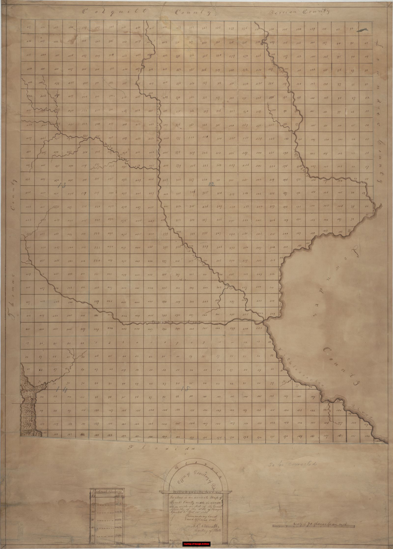
When Brooks County was created two years later, its northern boundary followed the existing Lowndes-Berrien, Lowndes-Colquitt, and Thomas-Colquitt county lines. Brooks received only the adjoining territory still belonging to Lowndes and Thomas. The part of the 9th District already in Colquitt remained there; neither the legislation nor the Newberry Library's county-boundary chronology records a transfer from Colquitt to Brooks.
The original Brooks boundary placed the future Hahira area in the new county. On November 21, 1859, the legislature changed the Brooks-Lowndes line to the east bank of Little River, returning that land to Lowndes after less than a year. The same act ordered Lowndes County to establish a new county seat along the Atlantic and Gulf Railroad, as near the county's center as possible. That seat became Valdosta. The act does not state why that particular land was transferred, but the change was part of the reorganization of Lowndes County and replaced the earlier lot-line boundary with Little River.
RandyMajors historical county lines map
This interactive map shows how county boundaries changed around the creation of Brooks County.
Sources
- Acts of the General Assembly of Georgia, 1825, 1826, 1855-56, 1858, and 1859, with the official 1837 digest of county-site laws.
- Newberry Library, Atlas of Historical County Boundaries, Georgia individual county chronologies.
- Folks Huxford, History of Lowndes County, Georgia, 1825-1941 and The History of Brooks County, Georgia, 1858-1948.
- Wire-Grass Reporter, November 17, 1858, report of the Brooks County bill's passage; and December 22, 1858, text of the act.
- Georgia Archives, 1867 Brooks County map, County Maps, Surveyor General, RG 3-9-66.
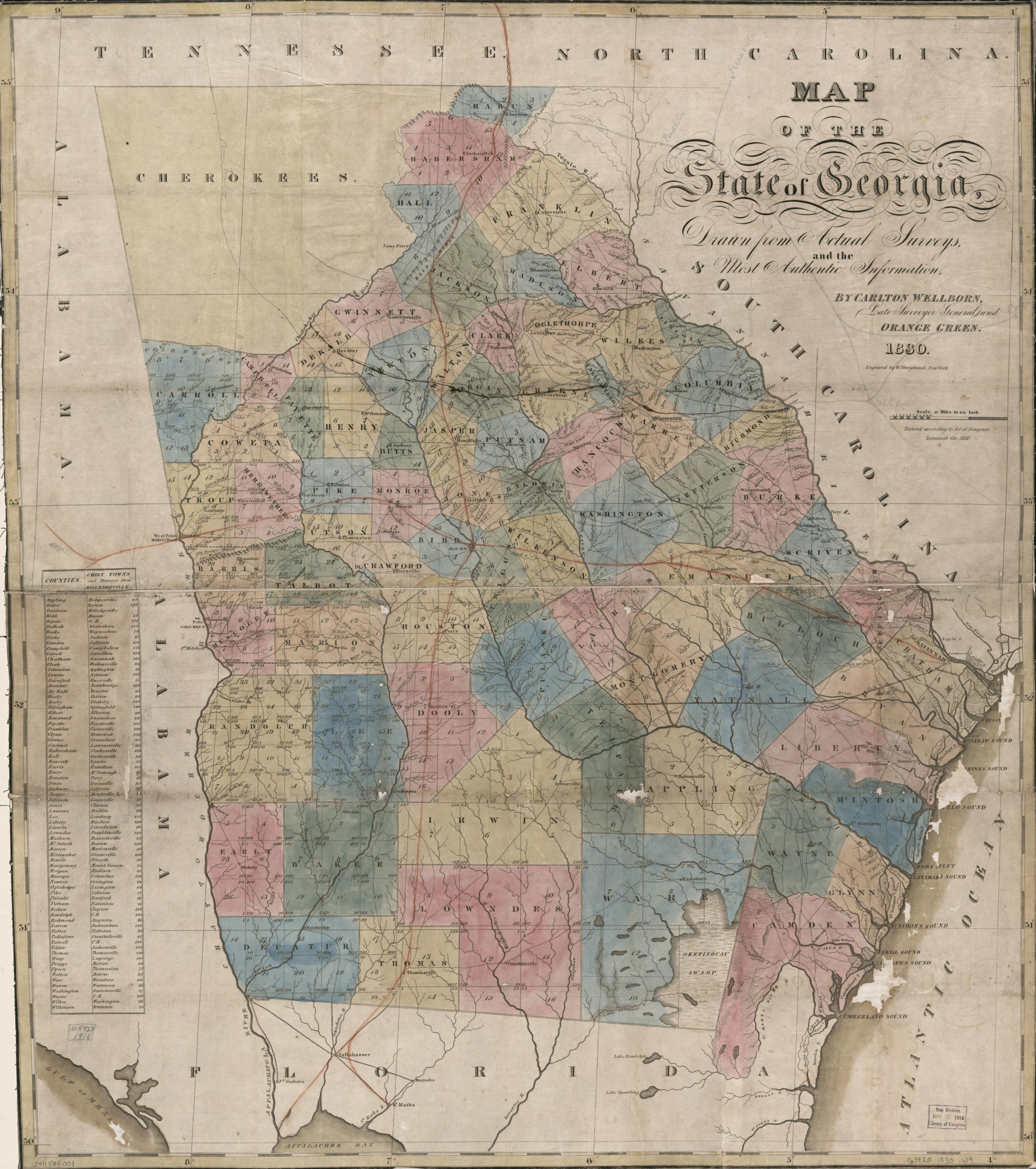
- Carlton Wellborn and Orange Green, Map of the State of Georgia, Drawn from Actual Surveys and the Most Authentic Information (1830), Library of Congress Geography and Map Division, call number G3920 1830 .W9, catalog record.
- Hamilton W. Sharpe's 1884 Valdosta Times articles and William Smith's 1880 first-court recollection.
- The evidence-graded Early History Profiles for the officials and landholders named above.